Hiking to Abrams Falls by way of Cades Cove and Townsend, TN.
As far as Smoky Mountain hikes go, the Abrams Falls Trail is one of the most conducive to beginners and weekend hikers. It’s an easy 5-miler (round-trip) that families can plan a weekend or day-trip around. Set aside 3 hours to fully enjoy the hike however, longer if you plan on enjoying the waterfall. Starting in Cades Cove, just outside Townsend, TN, the trek to Abrams Falls is a great way to get to know the Great Smoky Mountains National Park.
So lets talk about the trail itself, which ascends to 1,800 feet at one point. Once you reach Abrams Falls you are actually 300 feet lower than when you began. To get there, take Little River Road from Gatlinburg or Townsend (refer to map below), take the one-way Cades Cove Loop Road 4.9 miles and turn right onto a gravel road that leads to a parking area. If you reach the Cades Cove Visitors Center you’ve gone too far. The Abrams Falls Trail begins at the end of the parking area. You’ll cross the wooden bridge at Abrams Creek to start out. At the 0.5 mile mark, the Elijah Oliver Place is present and the trail goes left to begin the hike to Abrams Falls. For the most part Abrams Creeks will run right with the trail, with one exception when it veers to a highly fished horseshoe bend. Wilson Branch appears at mile 2.5 and the short side trail leads to the falls.
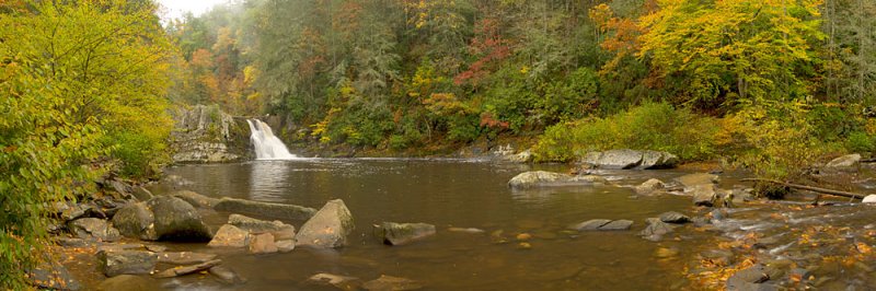
 You’ll notice that Abrams Creek resembles a narrow chute before transforming into a beautiful, yet violent 20-foot plunge over a ledge. This natural pool is a haven for swimmers and sunbathers during the hot summer months. In June, laurel and rhododendron frame the falls on its banks. The mist from the falls is a welcome break for hikers as an easy way to cool off and enjoy the park’s natural beauty.
For those looking for an even bigger challenge, the remaining two miles of the trail are much more isolated and unkempt. Ending at Abram’s Creek Ford, get on the Hannah Mountain Trail (left for 1.9 miles to the Rabbit Creek Trail at Scott Gap) and the Hatcher Mountain Trail (right 2.8 miles to the Cooper Road Trail and the Beard Cane Creek Trail). Or just retrace your steps to the Abrams Creek Trail and return to Cades Cove. You’ve completed the 5-mile round trip.
 A quick word of advice, wear hiking boots or shoes comfortable enough for a good walk. For day-hikers, running shoes should suffice, but the National Park’s uneven trails require hiking boots. Please stay on the trail. Hikers can easily lose their way when they leave the trail. If you get temporarily lost, try to retrace your steps until you cross the trail again.
Consider packing yourself some rain gear and a wool sweater as well. Both could be the difference between a terrible hike or a memorable one, especially if it rains. During the spring and summer you never know when one of those afternoon showers are going to pop up. Even during the summer rain can lead to hypothermia. Having said that, don’t let a fear of hypothermia, getting lost, or bears prevent you from enjoying the Abrams Fall Trails, or any other trail in the Great Smoky Mountains National Park for that matter.
Thinking about bears now? Most park rangers will tell you that more likely to see a bear’s behind as he runs off than meet one face to face. “Incidents” occur when people try to feed or bother the bears or bear cubs.
Directions: To get to the Smokies area from where you are, see directions to get to Gatlinburg or Townsend, Tennessee. From Townsend take TN 321 to the park entrance, turn right on Little River Road to Cades Cove. From Gatlinburg, turn right at the Sugarlands Visitor Center onto Little River Road and on to Cades Cove, where you will travel nearly halfway around the 11-mile loop road to the parking area for the 5-mile round-trip hike to Abrams Falls.
1 thought on “Hiking Townsend – Abrams Falls Trail”